
Storm Eowyn has wreaked havoc across Ireland, causing widespread damage and leaving hundreds of thousands without power. While the worst of the storm has passed, heavy snowfall and dangerous conditions are still anticipated, prompting warnings of further travel disruption.
Ireland is grappling with the aftermath of a devastating storm, Storm Eowyn , which ripped through the country last night, unleashing record-breaking gusts of up to 183km/h. Fallen trees and downed power lines have left a trail of destruction in their wake, with nearly one million properties across the island currently without power.
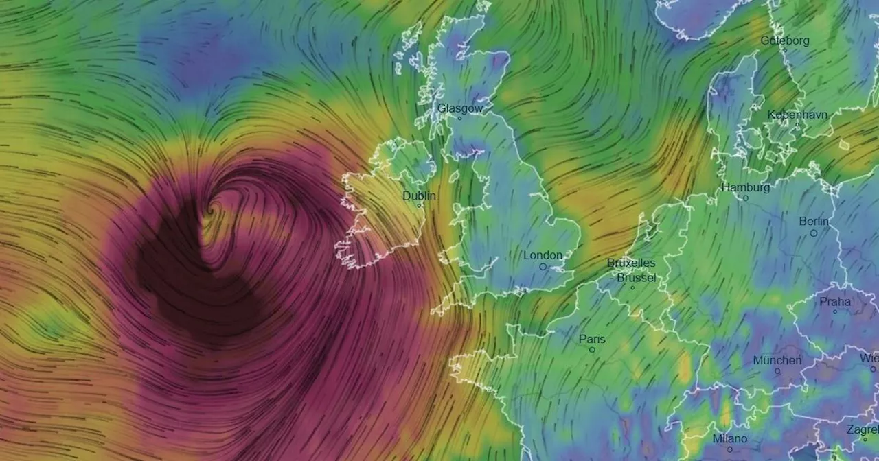
While Status Red weather warnings have been downgraded, the northwestern half of the country remains under a Status Orange wind warning, and the southeastern half faces a Status Yellow wind warning, both in effect until 4pm. However, Donegal County continues to bear the brunt of the storm, with a Status Yellow wind warning extending until 7pm and a new urgent warning issued by Met Eireann for heavy snowfall, adding to the already dire situation caused by the powerful Atlantic system.\This 12-hour alert, from 9pm to 9am, warns of hazardous travelling conditions due to icy stretches and snow showers. As the storm persists, forecasters predict plunging temperatures and dangerous conditions, potentially leading to further travel disruptions, including treacherous roads, delayed journeys, and more power outages. Met Eireann states that today's temperatures will range from 5C to 8C, but the windchill will make it feel much colder. For tonight, the forecast anticipates lighter southerly or variable winds, with frost and icy patches developing. Scattered showers, particularly across western and northern areas, are expected, with some hail, sleet, and snow, mainly confined to northwest areas later, interspersed with long clear spells. Temperatures will be cold, ranging from -2C to 2C.\Weather maps indicate snow spreading across the country on Saturday. Looking ahead to the weekend, Met Eireann predicts that Saturday will begin cold and crisp with frost and icy patches. Early sunshine will give way to cloudier skies as showery rain moves in from the Atlantic during the afternoon and early evening, possibly accompanied by hail and isolated thunderstorms. Temperatures will remain relatively low, ranging from 3C to 7C, with southerly winds freshening throughout the day. Saturday night will be cold, with clear spells and scattered showers, some wintry. These showers will primarily affect western and northern areas early in the night. Temperatures will dip to between -2C and 2C generally, with some frost and ice. Southerly winds will be mostly light to moderate, shifting southeasterly later in the night and increasing fresh to strong in coastal parts of the south and southwest. Cloud cover will gradually increase overnight, bringing rain to southwestern coastal areas by morning.\Sunday will bring wet and windy conditions, with a band of rain gradually spreading northeastwards through the morning and afternoon, some of it heavy and potentially thundery. The rain will clear northeastwards later, but scattered showers will follow, with more persistent and heavy rain likely to develop in the south and southeast in the evening. Temperatures will rise to between 6C and 10C in strong and gusty southeasterly winds, reaching gale force at times in some coastal areas, gradually decreasing to mostly moderate southerly winds away from the west coast later in the day. Sunday night will bring the possibility of persistent rain for parts of the south and east, otherwise a mix of clear spells and scattered showers, mainly in the west and south, some heavy and possibly thundery. Temperatures will range from 1C degrees in the north to 6C in the south and southwest, with mostly moderate southerly winds, but strong to near gale force winds are expected in coastal parts of the south and west. Monday will be windy with heavy rain and possible thunderstorms, interspersed with bright spells, and temperatures ranging from 4C to 9C. The blustery weather is expected to continue through Tuesday and Wednesday, with showers, some rain, and temperatures between 7C and 10C, followed by a calmer, brighter Thursday with light winds and temperatures around 7C to 9C.
Storm Eowyn Ireland Power Outages Snow Weather Warnings Travel Disruption
Ireland Latest News, Ireland Headlines
Similar News:You can also read news stories similar to this one that we have collected from other news sources.
 Drivers told 'do these four things' before Storm Eowyn batters Ireland this weekA number of weather warnings have been issued by the Met Office as Storm Eowyn is set to bring 90mph winds sparking chaos across Ireland
Read more »
 Gardai Issue Stark Warning: 'Do Not Approach Coastlines' as Storm Eowyn Batters IrelandIreland braces for the impact of Storm Eowyn, with a Status Red weather warning issued for the entire island, prompting a four-word warning from Gardai. The storm is expected to make landfall early Friday morning, bringing with it dangerous conditions. Gardai urge the public to stay indoors, avoid unnecessary travel, and prioritize safety. They warn of hazardous sea conditions and potential emergency service limitations during the storm's peak. Even after the Red warning expires, a Status Orange wind warning remains in effect, highlighting continued risks.
Read more »
 Ireland Batters Storm Eowyn: Red Warnings Issued as Life-Threatening Winds LoomIreland is on high alert as Storm Eowyn, a potentially destructive multi-hazard event, is set to unleash severe winds exceeding 130km/h, torrential rain, and snow. Met Eireann issued rare Status Red weather warnings for the entire country, urging residents to stay indoors, charge mobile phones, and prepare for power outages. Schools are closed, and non-essential travel is strongly discouraged. The storm is expected to peak on Friday evening.
Read more »
 Ireland Batters by Storm Eowyn: Status Red Warnings Issued for Entire CountryIreland braces for one of its worst storms in recent memory, Storm Eowyn, with widespread damage expected. Status Red weather warnings cover the entire country, signifying extreme danger from high winds, heavy rain, and potential snow. Authorities urge residents to stay indoors, schools and non-essential travel are suspended.
Read more »
 Storm Eowyn Batters Ireland: 1 Million Get Emergency Alerts as Red Alert IssuedIreland braces for the destructive force of Storm Eowyn. A Status Red weather alert, rare for the entire country, warns of life-threatening winds exceeding 130km/h, torrential rain, and even snow. Over a million people received emergency alerts on their phones, urging them to stay indoors and avoid travel.
Read more »
 Record-Breaking Storm Eowyn Batters Ireland, Leaving Hundreds of Thousands Without PowerStorm Eowyn, packing record wind speeds, has wreaked havoc across Ireland. Over 700,000 homes are without power, Dublin Airport has cancelled numerous flights, and transport services are disrupted.
Read more »