Ireland braces for another storm, Storm Herminia, following the devastation caused by Storm Eowyn. While not as severe, it is expected to bring strong gusts and heavy rain.
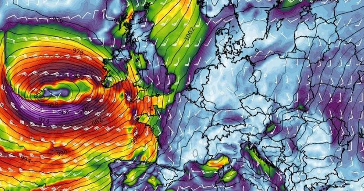
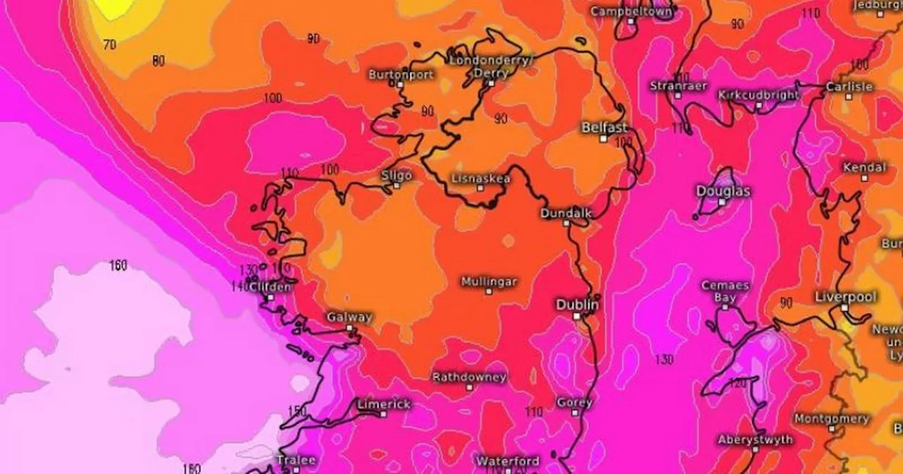
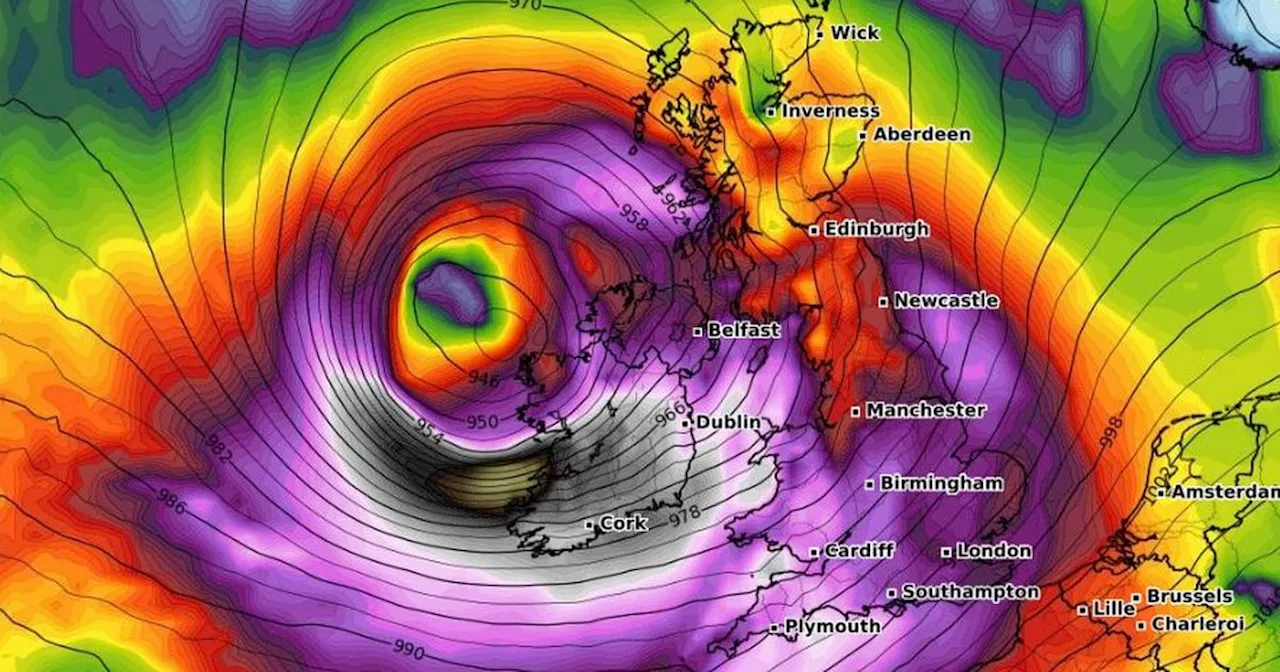
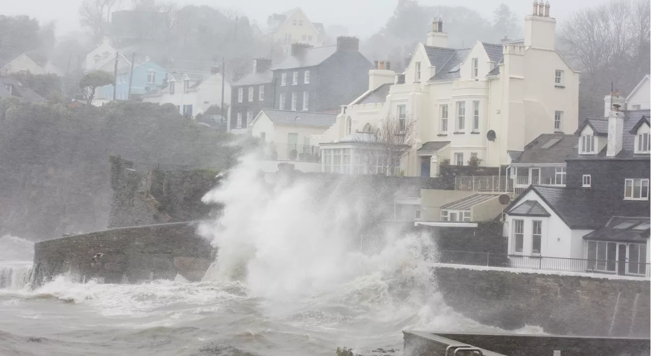
Ireland is still grappling with the aftermath of Storm Eowyn , which unleashed record-breaking gusts of up to 183km/h, causing widespread devastation. However, another storm is brewing on the horizon. The Spanish Meteorological Office has officially named it Storm Herminia , and it is predicted to bring more rain and wind to Ireland on Sunday and Monday. While Storm Herminia is not expected to be as severe as the Status Red Storm Eowyn , forecasters are issuing warnings for strong gusts.
Met Eireann, Ireland's national meteorological service, has provided a detailed forecast: \On Sunday, it will become wet and windy, with a band of rain gradually spreading northeastwards throughout the morning and afternoon. Some of this rain could be heavy and even accompanied by thunderstorms. The rain will clear northeastwards later in the day, but scattered showers are expected to follow, with more persistent and heavy rain likely to move into the south and southeast in the evening. The highest temperatures will range from 6C to 10C, with strong and gusty southeasterly winds, potentially reaching gale force in some coastal areas. These winds will decrease to mostly moderate southerly winds away from the west coast later in the day. \Sunday night will bring the possibility of persistent rain in parts of the south and east, otherwise, a mix of clear spells and scattered showers will prevail, mainly in the west and south, with some heavy and potentially thundery showers. Lowest temperatures are expected to range from 1C in the north to 6C in the south and southwest, with mostly moderate southerly winds. However, winds will be strong to near gale force in coastal areas of the south and west. \Looking ahead to Monday, Met Eireann predicts a rather windy day with showers or longer spells of rain, some of which could be heavy with the chance of isolated thunderstorms. There will also be some dry and bright spells at times. Highest temperatures will be between 4C and 9C, with fresh to strong and gusty southerly winds, potentially reaching near gale to gale force in some coastal areas of the south and west. Monday night will bring some clear spells but further showers or longer spells of rain are also expected. Lowest temperatures will range from 2C to 7C, with winds becoming cyclonic variable for a time and later becoming mostly moderate to fresh northwesterly. \Meanwhile, Irish weather expert Alan O'Reilly from Carlow Weather has advised the public that while Storm Herminia will bring unsettled conditions, the worst of the storm is expected to remain offshore. He stated that the storm will bring strong gusts, particularly to southern areas, but it won't be as strong as Storm Eowyn. He urged the public not to worry about any potential hype surrounding the storm, reassuring them that it won't be as severe as the previous storm. \In the aftermath of Storm Eowyn, restoration efforts for power and water are still underway across the country. Thousands remain without electricity following the damage caused by falling trees, flooding, and structural destruction. Emergency crews have been working tirelessly to repair the damage.
Storm Herminia Ireland Weather Storm Eowyn Met Eireann Alan O'reilly Carlow Weather Wind Rain Restoration Efforts
Ireland Latest News, Ireland Headlines
Similar News:You can also read news stories similar to this one that we have collected from other news sources.
 Storm Herminia Set to Bring More Wet and Windy Weather to IrelandIreland is bracing for another storm, named Herminia by the Spanish Meteorological Office, which is expected to bring wet and windy conditions to the country on Sunday and Monday. While not as severe as the recent Status Red Storm Eowyn, Herminia is expected to bring strong gusts and heavy rainfall, particularly in the south.
Read more »
 Storm Éowyn to Bring Heavy Rain and Strong Winds to IrelandMet Éireann has issued a weather advisory for Ireland as Storm Éowyn approaches, bringing the potential for heavy rain, strong winds, sleet, and snow. The storm is expected to make landfall on Thursday night and continue to impact the country throughout Friday. Strong winds and heavy rain are forecast for all parts of Ireland, with the potential for sleet and snow in the west and north.
Read more »
 Storm Eowyn to Bring Severe Weather to IrelandIreland braces for the impact of Storm Eowyn, the fifth named storm of the season, which is predicted to bring strong winds, heavy rain, and potential for snow and flooding. Met Eireann has issued a weather advisory, with warnings expected as the storm's path and intensity become clearer.
Read more »
 Storm Éowyn to Bring Heavy Rain and Strong Winds to IrelandStorm Éowyn is forecast to hit Ireland over the weekend, bringing with it strong winds, heavy rain, and potential for sleet and snow. The storm is expected to make landfall in the northwest, with Met Éireann issuing warnings for dangerous travelling conditions and potential power outages. The weather is set to turn wetter and windier on Thursday night as Éowyn approaches, with widespread rain and strong southerly winds. Friday will see very windy conditions with potential for wintry showers, and the unsettled weather is expected to continue into the following weekend.
Read more »
 Storm Éowyn to Bring Strong Winds and Disruption to IrelandMet Éireann has issued a status orange wind warning for the entire country as Storm Éowyn approaches. The storm is expected to hit Ireland overnight on Friday, bringing gale force winds, damaging gusts up to 130km/h, fallen trees, power outages, and difficult travel conditions.
Read more »
 Storm Éowyn to Bring 'Very Serious' Winds to IrelandMet Éireann has issued a Status Orange weather warning for wind ahead of the arrival of Storm Éowyn, which is expected to track across the entire country on Friday. Gusts of up to 130km/h are possible, bringing risks of fallen trees, power outages and travel disruption.
Read more »